
This is the oldest trip in the travel section of my website, dating back to the period before I even owned a camera. The inspiration for purchasing a camera of my own was my time spent playing Dance Dance Revolution (DDR), where I wanted the ability to snap digital pictures to record my best scores. I picked up a cheap camera for that game in the summer of 2005, and this trip took place a few months earlier in March, when I borrowed the family camera from my parents for a few days. The inspiration for this trip was a visit to see my brother, who was doing a junior year study abroad semester in London. I was flying out to see him during my weeklong spring break and since I was flying on Icelandair anyway, I decided to splurge on one of their two day vacation packages and briefly stop to see Iceland on the way. It wasn't too expensive since March is not a popular month to visit a country sitting just below the Arctic Circle. This was taking place during my first year in graduate school at the University of Maryland, and I vividly recall doing some of my reading assignments on the plane ride across the Atlantic. I would be flying back to Britain repeatedly over the next few years for my own Ph.D. research at the British Library.


I flew into the airport at Keflavík, located on a small spit of land at the extreme southwest corner of the island. It takes about an hour's drive to travel from the airport to Reykjavik, the capital city of Iceland, where I would be staying for this brief two day trip. Fortunately for me, the whole travel package for this trip had been arranged ahead of time through a deal with Icelandair, and I was able to take a bus run by the airline company to the hotel where I was staying. This hotel was not surprisingly also owned by Icelandair and was called the Loftleiðir, the unattractive building of concrete and green paneling pictured above. This place was comfortable enough and I believe that it was actually the largest hotel in the whole country when I visited in 2005, but it wasn't a terribly attractive place from an aesthetic perspective. I had the chance to watch a little Icelandic television while I stayed here, as well as the German version of "Who Wants to Be a Millionaire". The closest building to this hotel was something known as Perlan, the domed building in the second picture up on the top of a hill. Perlan (translated as "the Pearl") is a revolving restaurant with an observation deck that provides arguably the best views of the city of Reykjavik. I took this next group of pictures from that observation deck on the top of the hill:

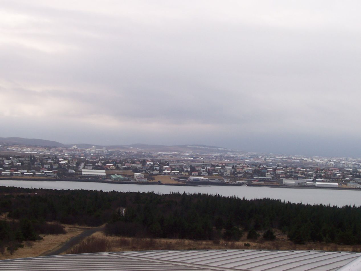


Reykjavik is a small city and I could see virtually all of it from this vantage point. The first picture showcased the view towards the oldest part of the city, with the spiky point of the Hallgrimskirkja church rearing up in the center. The Icelandic government buildings and the waterfront were off in that direction as well, only too short to be seen from this distance. The second picture looked south, across a narrow inlet of water and towards some of the city's suburbs that stretched off into the distance. The third picture looked northeast towards the Laugardalur district of Reykjavik, the other part of the city most heavily developed with structures. Note that even here in the most heavily "urbanized" part of Iceland it was still possible to see barren, snow-covered hills rising up in the background across the water. Those sentiments were even more pronounced in the last photo, which was taken from the same location on top of Perlan and appeared to be looking off into an isolated coastal region. Yes, those empty patches of tough brown grass were also within the Reykjavik city limits. The entire greater metropolitan area including the suburbs has a population of about 200k people, and the whole area is not densely inhabited. Iceland is a country of wide open spaces.

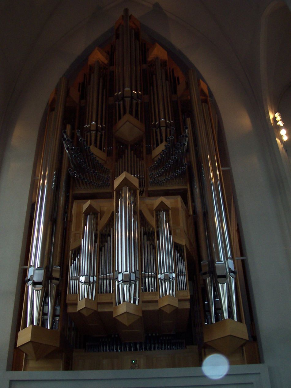
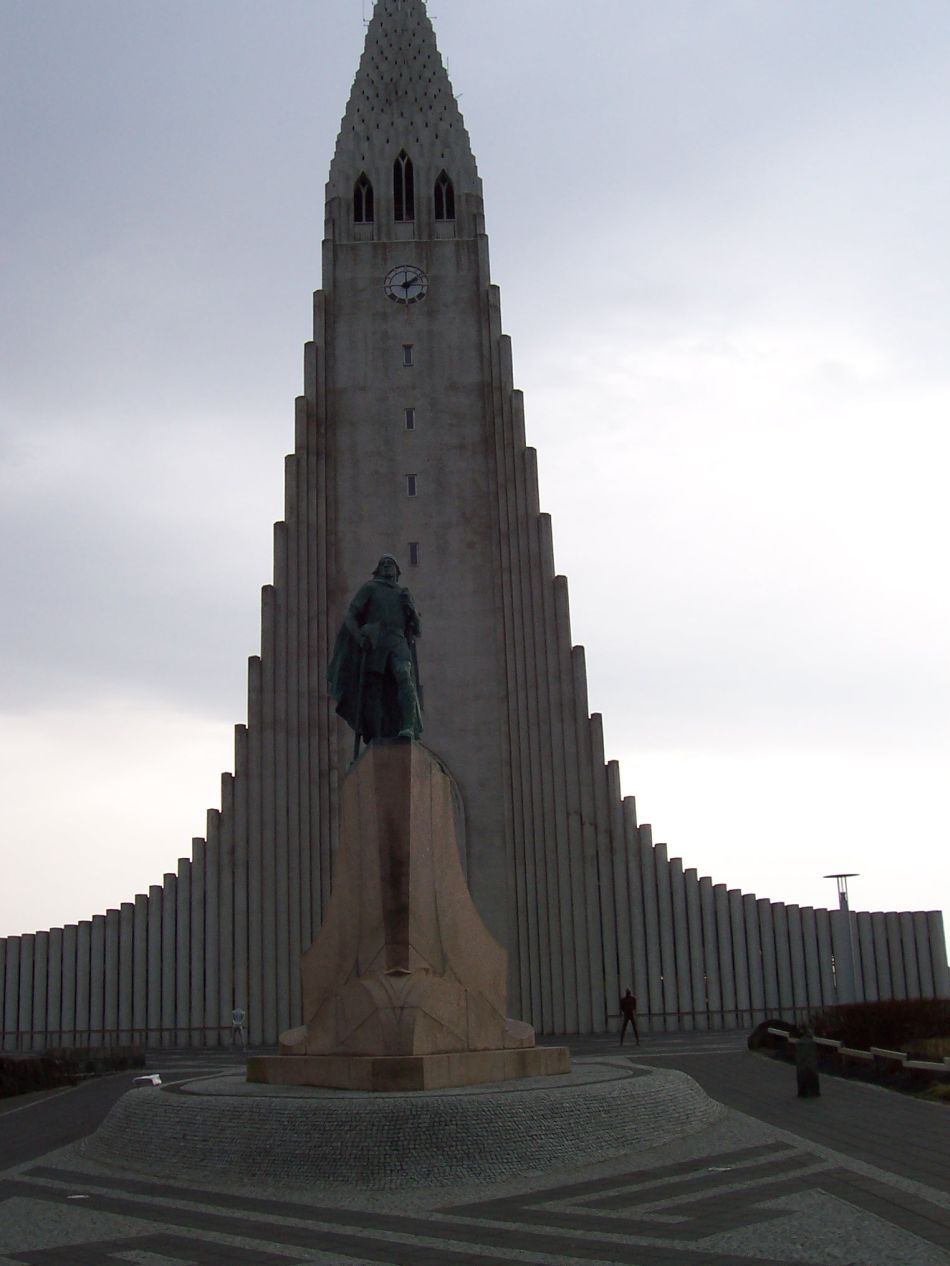

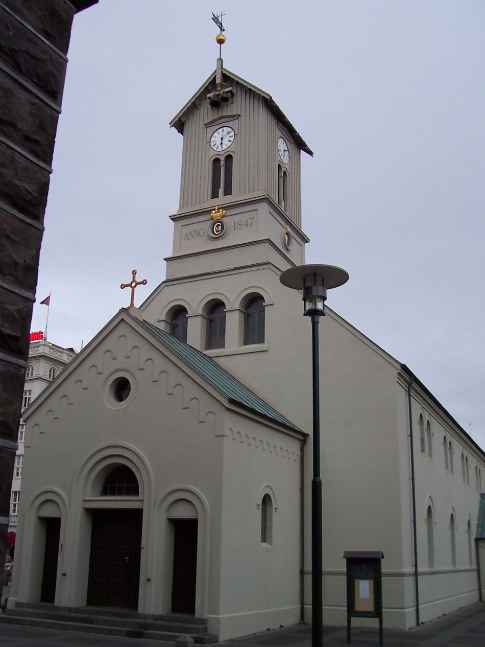
This next group of vertically-taken pictures were from a tour of the city provided again by Icelandair and included in my travel package. The most impressive location was Hallgrimskirkja, the imposing church that dominated the skyline of the central part of Reykjavik. Hallgrimskirkja is a relatively recent creation and was completed only in 1986. Apparently the construction started just after World War II finished in 1945 and then needed more than four decades to be completed. Hallgrimskirkja stands 75 meters (250 feet) tall which makes it the tallest church in the country and one of the tallest buildings of any sort. The design is most often compared to a rocket ship getting ready to blast off into space. As for the interior, it has a surprisingly soft and airy feel, with lots of bright light coming in from the tall non-stained glass windows that ring the walls. Iceland's population is almost entirely Lutheran in denomination, and like many other Protestant churches, this one had a spartan design with almost no decorations at all. The one exception was the beautiful pipe organ in the back, which stands over 15 meters tall and has more than 5000 individual pipes. Hallgrimskirkja allows visitors to ascend up to the top of the tower for outstanding views of the surrounding city, something that I did not know about at the time of this tour and wish that I had been able to see. I hoped that I would be able to do so if I came back to Iceland, but then when I did return, Hallgrimskirkja was the one place that we were unable to visit due to lack of time. Well, perhaps on a third trip then.
There's also a famous statue of explorer Leif Eriksson that stands in front of the church. This was a gift from the United States in 1930 to commemorate the thousandth year anniversary of the meeting of the first Althing, the medieval Icelandic pseudo-parliament. It stands on a little pedestal and serves as a landmark in its own right. The last picture above comes from the Ásmundur Sveinsson Sculpture Museum, the former home of an artist that was turned into a small museum showcasing his works. I don't know enough about this artist to comment further, but it was a pleasant enough small gallery. Iceland as a country has always been given over to literary and artistic pursuits, probably because of the long winters with little else to do. Rekjavik has been adding museums at a rapid pace since my initial visit in 2005, and when I went back in 2016 there were quite a few more places like this to tour.

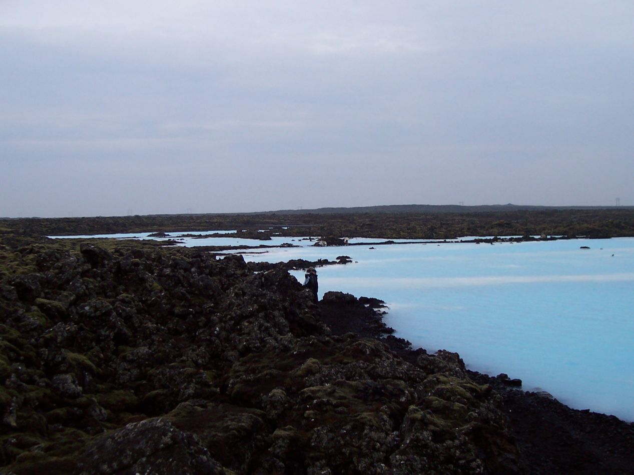


After seeing a good portion of the city, another Icelandair bus took me that evening to visit the Blue Lagoon (Bláa Lónið). This is probably the most famous tourist attraction in the whole country, a spa destination known for its outdoor lagoon with mineral-rich waters. I was surprised to find that the Blue Lagoon was located in a field of dried lava from some eruption that took place several hundred years ago. This was a very barren landscape where little in the way of plant life could grow, and it appeared at times as though the bus was driving along the surface of the moon. The water in the lagoon comes from a geothermal power plant located about a mile away - something that the tourist brochures don't talk about very much - and which was easily visible off in the distance. The water was a brilliant light blue color with milky white patches running through it from the mineral runoff in the rocks. I don't want to give the impression that I'm slamming the place too much though because bathing in the waters of Blue Lagoon was incredibly relaxing. There were very few people here in the evening on a March weekend, and the contrast between the cold weather outside and the warm waters of the lagoon was quite soothing. Maybe the Scandinavians and their obsession with saunas and hot springs are on to something after all. It even began to rain lightly at one point and it didn't seem to bother anyone very much. With the steam rising up from the heat of the nighttime waters, the whole experience had a bit of an otherworldly feel to it. For anyone who wants to visit the Blue Lagoon, I recommend headed there at night when it's much less crowded as compared to during the day.


That was all for the first of my two days in Iceland. The next morning my trip package included a tour heading on something known as the "Golden Circle", a circuitous route to several popular tourist attractions located within a few hour's drive of Reykjavik. This day trip would be taking place on a tour bus provided by the airline; it was about half full on this occasion with roughly 20 people on board. Most of them seemed to be Europeans and I recall having a conversation with a young French couple who were very polite as we each practiced our foreign language skills. The bus headed east out of Reykjavik and within ten minutes we were out into the wilderness with hardly a sign of civilization, just a road winding its way off towards the horizon. Here in late winter, all of the small mountains were still covered in snow at their peaks and there were patches of white hidden in the folds of the ground where the sun struggled to reach. For that matter, the weather had been overcast ever since I landed at the airport and showed no signs of letting the sun burst through. This is quite common for Iceland, which gets a lot of rain (and occasional snow) throughout the year due to its location in the North Atlantic. And I should also mention the wind, which was quite strong everywhere that I went and never seemed to let up. Iceland has virtually no trees anywhere in the country due to the poor soil, and that means nothing to block the wind as it screams across from the open ocean. This is a very unique location from a climatic perspective.

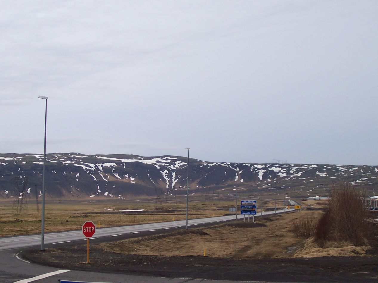


Our first stop on the bus tour was a small village named Hveragerði, pictured above with a total population of just over 2000 people. The reason why the tour bus stopped was to showcase the greenhouses in the town; Hveragerði is known for having a bunch of them and the tour took our group to see an example. This is one of many places in Iceland with active hot springs, used here to provide heat for the local greenhouses. For some reason I didn't take any pictures of the greenhouse tour so you'll have to use your imagination of the plants on display. I was more struck by the natural scenery that dwarfed this little town on all sides. Snow-capped hills reared up behind it to the north, while another series of hills made a barrier that had to be surmounted to travel west towards Reykjavik. Our tour bus had laboriously traversed those hills to reach this place earlier. Meanwhile, to the east and to the south there was a flat plain that contained... well, nothing. It was flat ground covered by tough grass and the occasional isolated farmstead as far as the eye could see. I felt like I was on the Great Plains of the United States, only with snowy mountains and volcanoes around to spice things up a bit.

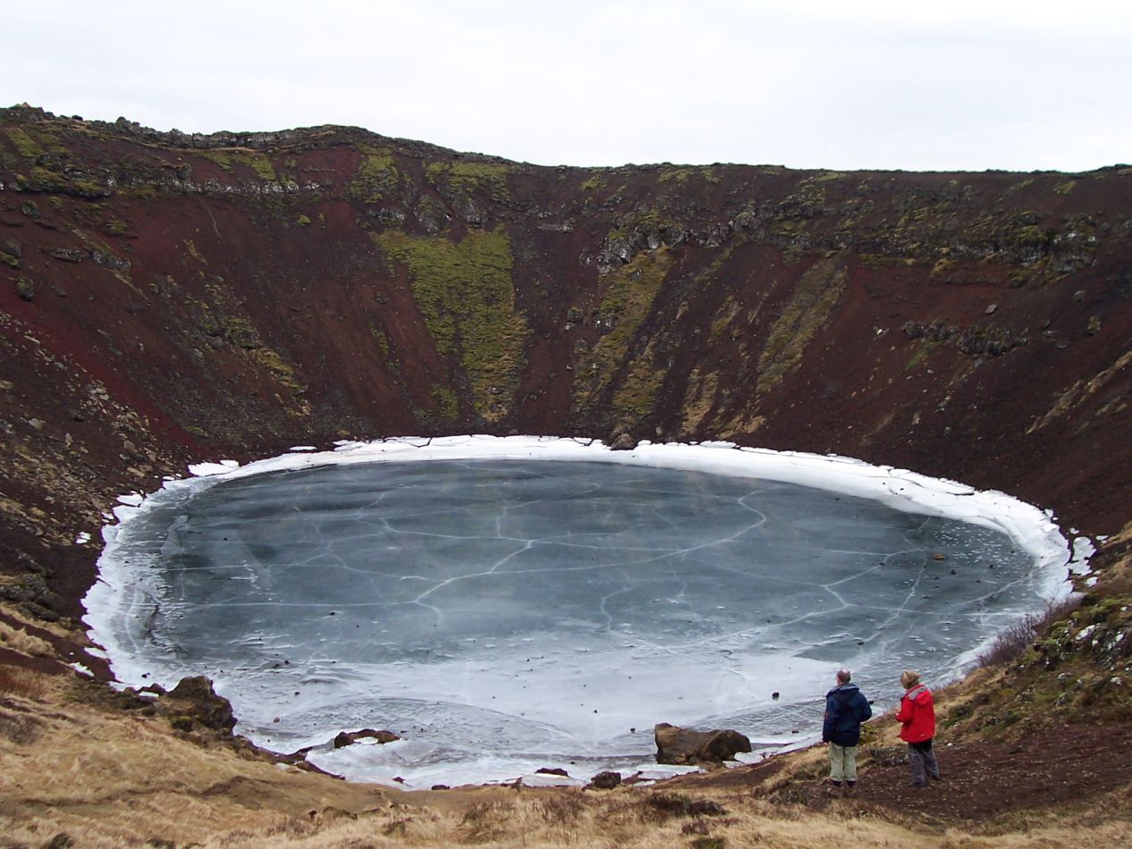


The next stop took place at a natural phenomenon known as Kerið, although I had to look that up afterwards since there were no signs at the site itself. This was a volcanic crater lake formed as the land moved over a localized hotspot, with an easily recognizable caldera containing a lake at the bottom. The place is about 55 meters (180 feet) deep and 275 meters (900 feet) across from side to side at the top. During the warmer months of the year the lake is full of cool water, but here in late winter it had all frozen over with ice. There was a rough path that led down to the lake's surface and I poked around a bit at the rocky shoreline. The ice was starting to break up and it was not safe to walk out onto it. This was one of the wilder natural formations that I'd seen, and it was especially fun to be here when the lake was frozen over. For that matter, I was also impressed at the utter isolation in the vicinity of Kerið; there was absolutely nothing at all in this area. Our bus would sometimes drive for minutes on end without seeing a single car passing on the road in the other direction.

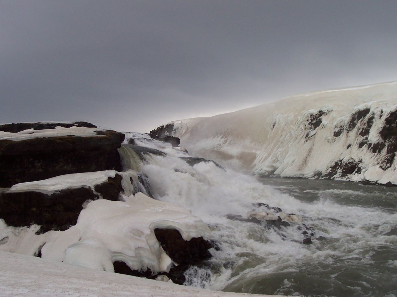


The biggest highlight of the whole tour was the place where we stopped next, the huge waterfall known as Gullfoss. Translated as the "Golden Falls", this waterfall drops about 32 meters (100 feet) into a canyon below and has become one of the most popular tourist attractions in Iceland. There was a plan earlier in the 20th century to turn the falls into a hydroelectic plant, which was blocked due to local activists until custody over the land eventually passed to the Icelandic government, which has made it a protected natural site. Most of the pictures that I've seen of Gullfoss take place during the summer, and indeed when I returned here a decade later in July, the place was swarming with tourists. The falls were a completely different story in winter, however. Our bus was the only one in the parking lot and there were perhaps two dozen people total at the site. The waterfalls kick up a lot of spray as the torrent of liquid races over the cliffside, and here in the winter a lot of that mist freezes due to the cold. The natural result was a series of fascinating ice patterns along the rocks, especially right at the edge of the waterfall where a thick layer of snow and ice had created a fat overhang of white. Combined together with the patches of snow clinging to the rock walls that surrounded the canyon, this was an amazingly beautiful spot. 


There was a viewing platform next to the falls where they could be seen up close. However, reaching that platform was no easy task. The only access point was a narrow trail down from the parking lot at the top of the cliffs, and that path was covered in snow that no one had bothered to clear. Furthermore the trail was very icy due to the water that kicked up from the falls and then froze. Only by holding onto the little guiderope that ran along the side of the path was I able to make it to the bottom without falling, and then it was needed again to climb back up to the top on the way back. There was virtually nothing in the way of security here and anyone could have fallen off the edge if they slipped in the wrong place. Perhaps for that reason most of the tour bus stayed up at the top of the cliffs and only a few people joined me in making the walk down. I was glad that I did though, since it let me see the waters of the river up close. This was an incredible place to visit in the winter.


The tour group stopped next at a hot springs area known as Geysir, and yes, this is where the word "geyser" comes from that's passed into the English language. There were about half a dozen places where jets of hot water would shoot up out of the earth due to underlying geothermal activity. I tried my best to capture this on film and ended up failing; I vowed that if I ever came back again I would make sure to get a better picture, and fortunately that did happen on my return trip. This was another location that was mostly devoid of human activity aside from a small cafe and gift shop. The tour group had lunch here and I picked up my one souvenir of the trip, a small wooden carving of the god Thor done in a traditional Icelandic design. I still have that little carving on my desk along with a bunch of other travel keepsakes.

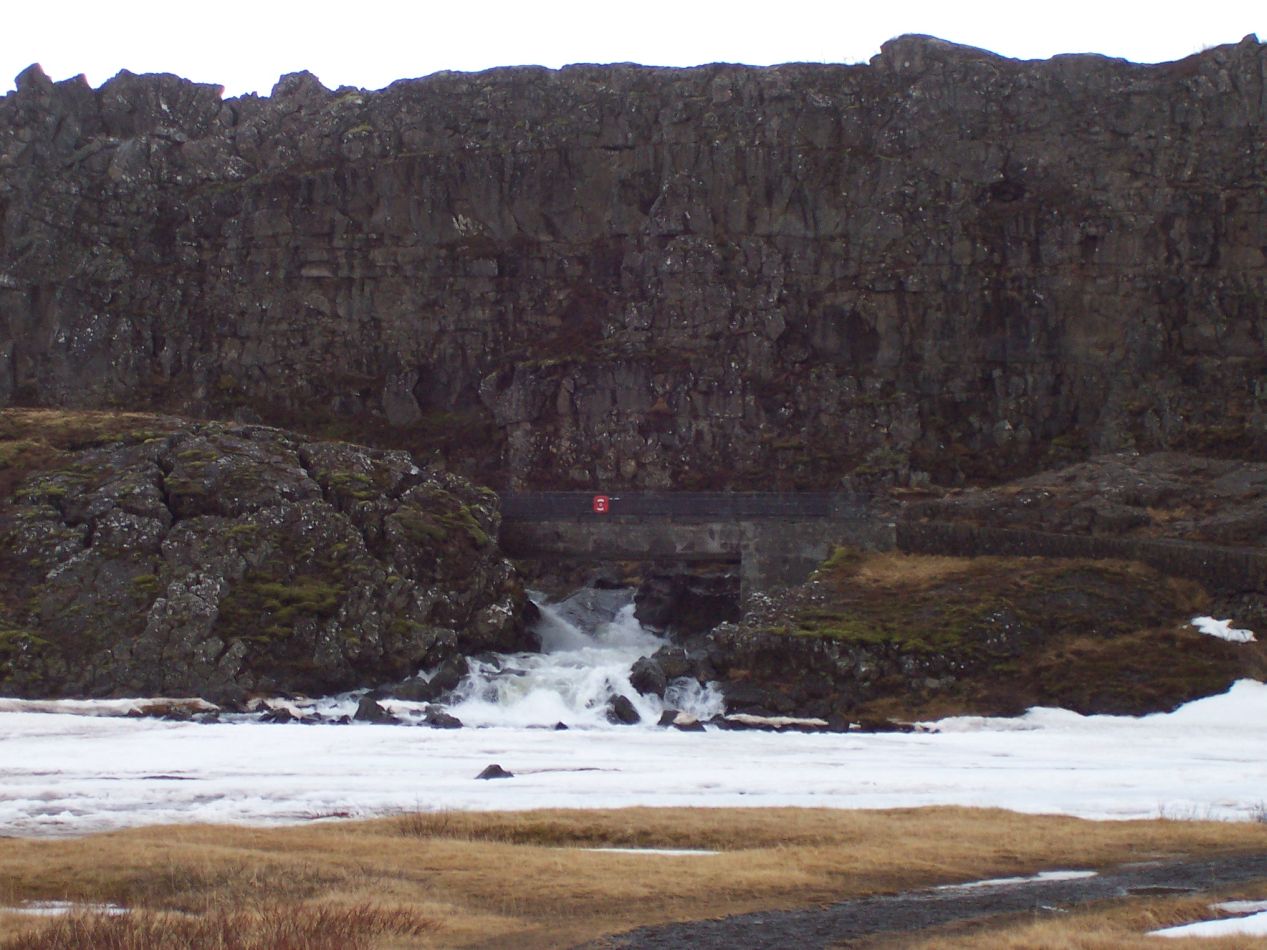


The last stop on this tour bus excursion took place in Þingvellir National Park, another geologically active area with a great deal of historical significance. Þingvellir (pronounced like "Thingvellir" in Icelandic) sits directly atop the Mid Atlantic Ridge where two different tectonic plates are in the process of moving in different directions. Millions of years from now, this activity will tear Iceland apart and create two separate islands with the sea flooding into this region. Þingvellir is also a historically important location, since this was where the medieval Icelandic Althing met in centuries past. Those gatherings took place from about 930 to 1270 AD on top of the hill known as the Lögberg, or "Law Rock" in Icelandic. There's a white pole placed on the spot today to indicate the spot. Here in the winter the park was a rather desolate location, the bridges and walking paths empty of other travelers, and with snow dusting the grasses. The sky remained overcast above and the waters of Þingvallavatn lake to the south looked extremely cold.

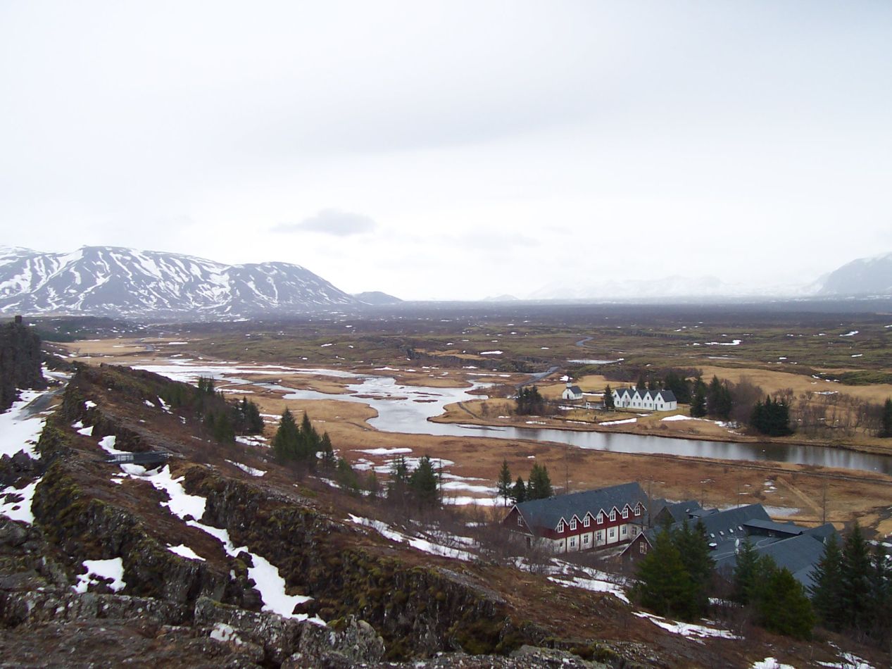


There are two levels to the main tourist area at Þingvellir National Park: the bottom of the cliffs where the Lögberg is located and then the view from the top of the cliffs. Our tour group had started at the lower level and then piled back onto the bus to head up to the top. In warmer months of the year there are walking paths between the two ends of the cliff face, but no one seemed to eager to try hiking around in this cold weather. I was struck at how much snow had piled up inside the many crevasses that wormholed through the rocks. Snow and ice were built up anywhere that the sun had difficulty reaching, and likely had been accumulating throughout the winter. Off in the distance, the surrounding mountains in this region also seemed to have more snow cover than the other stops elsewhere on this day. This was a place that would be a lot of fun to explore on a warm summer day when the weather conditions were much different.


The tour bus brought the group back to Reykjavik and I used the remaining late afternoon light to do a bit more sightseeing in the downtown portion of the city. The first structure pictured above is the Icelandic Parliament building, with its small and rugged stature reflecing the national character of the country. As the name on the building suggests, this was constructed in 1881 and still remains in use today, although much of the administrative work takes place in surrounding buildings. Standing right next to it is Reykjavik Cathedral (Dómkirkjan í Reykjavík), the official seat of the Bishop of Iceland and head of the national Icelandic church. It was closed when I arrived and I still haven't had a chance to see the small interior. Reykjavik Cathedral is one of the oldest structures in the city, which didn't become the capital of Iceland until the 19th century. The white building with the wooden door is the Prime Minister's Office (Stjórnarráðið) of Iceland, one of the few places in the city older than the cathedral. It dates back to the late 18th century and was used at times as a prison before becoming the residence of the Danish governor of Iceland and then, eventually, the Icelandic prime minister. From these public buildings in the center of the downtown, I walked the mile back to my hotel, passing by the huge Hallgrimskirkja church with its statue of Leif Eriksson one more time. I was thoroughly exhausted from travel and time zone differences at this point, and went to sleep early for my flight the next day to London.
Even though this was only a short stop in Iceland, I felt as though I had learned a great deal about the small country and its inhabitants. It was such a unique place that I wanted to come back again to see more of the beautiful natural landscape. In other words, for the Icelandic tourism office this package deal offered through Icelandair had worked exactly as planned.  When I did come back in 2016 together with Liz, we had a wonderful time and wanted to make plans to return yet again for a third trip. This was a case where the country really did speak for itself. I hope you enjoyed this small sample of Iceland - thanks as always for reading.


